Map Thread XX

Status
Not open for further replies.
lol yeah. It is basically based on David Bowie, with 'Ibiza to the Norfolk Broads', his birth place, and his death place, etc, ISOTed to a blank Earth. I have extended far longer than is normal for an ISOT series (beyond 25 maps) but I like doing it too much, so.

So you are saying this is supposed to be an ISOT based on a song by David Bowie?
 
Oh, they would have liked that. But Maginot line or not it’s easier to get into France if you also control Belgium. Shortly after the event Germany staked claims on the ethnic german provinces of Belgium annexed after WW1. Belgium said no, got invaded. To the south Luxembourg just surrendered without fighting. Britain didn’t dare step in to help them. Knowing they would get their asses kicked without France around. Belgium is still a German protectorate of sorts, while Britain seized the Congo with tacit approval from Germany as long as they didn’t intervene in mainland Europe.

So, France proper and all direct colonies were replaced by virgin, uninhabited land. From a world that never had humans but is otherwise identical. Let’s say (not part of the previous post but my head canon to the scenario) they were ISOT to a Virgin Earth on the other end. That part is based on territory, so everyone there goes along. The second part is that in France’s protectorates (plus the new Hebrides islands) and in any other country, all French government and military presence is removed.

So non ethnic French people living in the French colonial empire are ISOT to a virgin earth. For example: Ivory Coast, the whole colony and everyone living it in is affected by the event. From the perspective of the rest of the world they have just disappeared. But in the protectorates, for example Tunisia, only French military and government personnel are gone. Along with any other kind of official presence, though I can’t think what that would be.On the other end they appear in the nearest French or colonial city. Local governments and all civilians are unaffected.
I see
 
theomachy.png


For this.
 
Last edited:
The Caribbean Salinity Crisis
View attachment 633747
A butterfly flaps its wings, and geology is altered slightly. The Lesser Antilles and Puerto Rican subduction zones are a bit more active, and the volcanic activity opposing them a bit more frequent and extending slightly more to the northeast. About three million years ago, the volcanism had advanced to the point where North America connected to South America, first at Panama and shortly thereafter at Trinidad. The cutoff of the Central American seaway dramatically cooled the global climate, while the landlocked Caribbean Sea, located in dry latitudes, quickly drained. Within a few thousand years, it had reached an equilibrium with three large seas located two to three kilometers down, which has been maintained for the past three million years.
The seas were initially highly saline, much as the Messinian era Mediterranean was, but the Mississippi and Magdalena rivers have flushed out most of it by now. The northern Sea, the Mexican Sea, lies 2.1 km below sea level, the middle Cayman Sea lies 3.4 km down, and the southern Caribbean Sea lies 2.9 km down. Air pressure ranges from 25% higher at the Mexican sea to 40% higher at the shores of the Cayman sea. Ecologically, they’re like nothing else on Earth. The mouth of the Amazon averages 28 C, the mouth of the Congo 26. The mouth of the Mississippi averages 33, the mouth of the Magdalena 42 C. The life that has crept down from the highlands into the Mesozoic rainforests and scorching deserts tends to be small and gracile, and tremendously weird.
Early humans killed nearly all the megafauna in the American uplands, but the sunken Caribbean basins are hardly habitable for unadapted humans, and over the thousands of years it took for them to descend to the shores, the animals got wise to these strange new predators. Scimitar cats, Camelids, dwarf Elephants, giant teratorns, ground sloths, gompotheres, and more still range about the Carib seas. Some six thousand years, early agricultural efforts began in the Jamaican midlands, and a quite sophisticated civilization developed in the basin. Mexico is much more of a desert than in our world, as is the Mississippi basin, and so the city states of the sunken seas had little contest except from the strange Incans.
For millennia, they developed in their own strange bubble, domesticating some of the megafauna and killing others, sophisticating agricultural techniques, waging wars and mining the metals with which to fight them. For someone born and raised in the deeps of the Cayman or Caribbean, sea level feels as high as Lhasa Tibet would to us. The air is breathable, but only barely, and any serious mountain above sea level is potentially fatal. Their material wealth and sophisticated technology allowed them to enlist highland sepoys in the Bahamas, Mississippi, and Mexico to serve as explorers and in trade networks, and through these networks and a few brave explorers some corners of civilization are aware of most of the Americas, but there is little of note outside the deeps. Lake Titicaca is 7 km above the Cayman sea, and so the Incans and the Sách̀ Shum cannot even visit the others homelands, and both regard the lands around sea level as generally undesirable.
And then one day in the fall of the 1492nd year after the birth of Christ, a foolhardy Italian explorer sailing Spanish ships lands on the shore of a Bahamian island, and the world changes forever.
So how would this affect weather patterns for the area?
 
anorithil.png

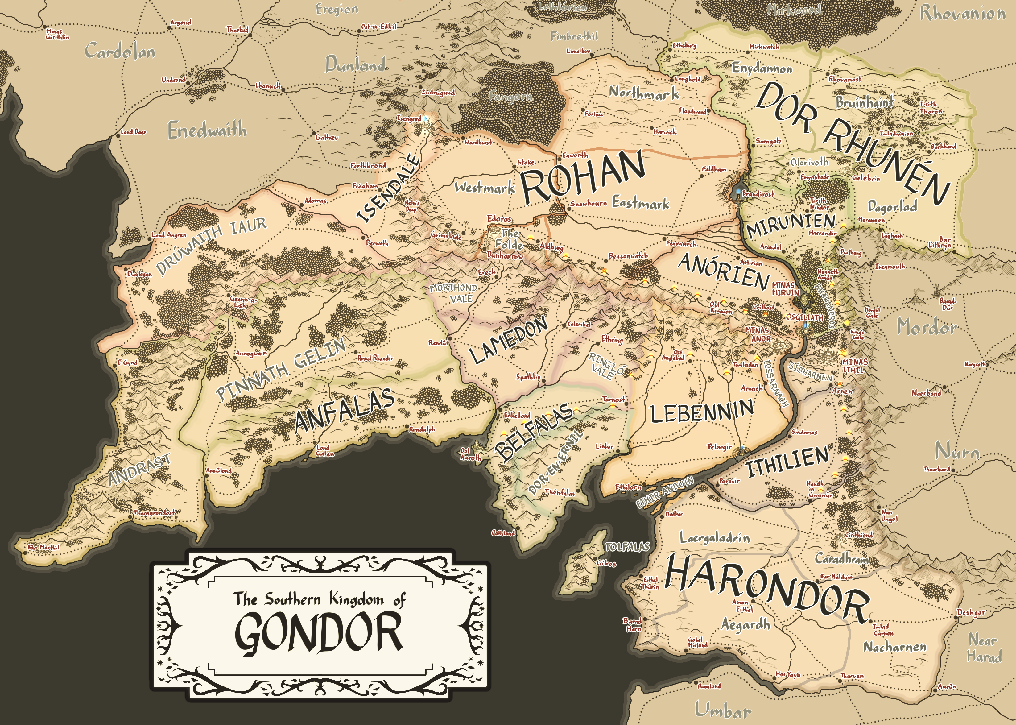
One Does Not Simply Build A City In Front of Mordor: An Alternate History of Gondor
The premise of this map is Isildur builds the city of Minas Ithil atop the Emyn Arnen instead of the Morgul Pass at Anarion's nagging over the safety of civilians. The butterflies set off by this is one of a defensive Gondor that is far better prepared against external threats but dominated by the rule of the Gondorian Tripolis: Osgiliath, the political and economic hub of Gondor; Minas Anor with its guild halls and noisome streets; and Minas Ithil, a quiet city of the arts and mysticism. The history of the Southern Kingdom would come to be shaped by the Kin-strife, a civil war fought between the land-based domains of the Tripolis and the nobility of the seaward south.

Whatever I have not sourced from canon are derived from LOTRO, Lindefirion, MERP, even the Middle-Earth: Shadows series. The flags are of my own design. Some notes within the spoilers:
Capital: Osgiliath
Ethnicities: Dunedain, Daen (Men of the Mountains), Rohirrim, Dunlendings, Haruze, Druedain, Sindar Elves, Nandor Elves, Gondorians of mixed descent
Government: Feudal Monarchy (under joint regency of the Ruling Stewards and Ruling Captains)

1st column of flags:
Lamedon- capital: Calembel; territory type: province; autonomous districts: Morthond Vale (Erech), Ringlo Vale (Ethring)
Anfalas- capital: Lond Galen; territory type: province; autonomous districts: Pinnath Gelin (Rond Rhandir), Andrast (Thargrondost)
Isendale- capital: Freaham; territory type: fief of House Siric; autonomous districts: Druwaith Iaur (Geann-a-Lish)
2nd column of flags:
Anorien- capital: Minas Anor; territory type: royal demesne (under regency of the Ruling Captains of the House Eorl); autonomous districts: Lossarnach (Arnach)
Rohan- capital: Edoras; territory type: fief of House Eorl; autonomous districts: Eastmark (Snowbourn), Westmark (Grimslade), Northmark (Forlaw)
3rd column of flags:
Ithilien- capital: Minas Ithil; territory type: royal demesne (under regency of the Ruling Stewards of the House Hurin); autonomous districts: Thenidarnen (Arnen)
Harondor- capital: Galadrin; territory type: fief of House Hurin; autonomous districts: Nurithilien (Haudh in Gwanur), Ethir Harnen (Gobel Mirlond), Aegardh (Tharven)
4th column of flags:
Lebennin- capital: Pelargir; territory type: province; autonomous districts: Ethir Anduin (Ethilorn)
Belfalas- capital: Dol Amroth; territory type: fief of House Dol Amroth; autonomous districts: Dor-en-Ernil (Linhir), Tolfalas (Gilros)
Dor Rhunen- capital: Rhovanost; territory type: military frontier
-Strictly military fortifications are built at the Morgul Pass: the Nimannon (White Gates), watched over by the Tower of the Seer (Cirith Ungol) and the Tower of the Sage (OTL Minas Morgul). A Nazgul attack and Ithilian counterattack (led by King Earnur and Captain of the Hosts Baranor, a man of Haradrim origin) results in the former being corrupted to become the Morgul Gate and the latter to become the King's Gate, defended by the Gatewatch, an elite guard equipped with enchanted gear made by the rune-carvers of Minas Ithil.
-4 chains of beacons are built early on: the western chains are visible from Minas Anor, the east to Minas Ithil. The northwest hills formerly extended to Isengard but were ruined over the years; those that remain lead to Edoras. The southwest chain follows the positions of the hills in LOTRO. The northeast passes by the King's Gate and ends at the Morannon, primarily concerned with Orc attacks from Mordor. The southern chain ends in Haudh in Gwanur.
-The Ithilduin still became the polluted Morgulduin; the river now cannot be easily forded and all communications/travel must be by bridge. The bridge near the King's Gate is less secure, so Ithilien's administration is split: the forested frontier of the north is Ithilien proper, linked to the city via the nearer bridge along the Anduin; the south is the hilly pastoral Thenidarnen.
-With the fall of the line of Anarion, rule of Gondor is split between three powers: the Ruling Stewards of House Hurin in Minas Ithil, the chief executive and the face of Gondor in foreign affairs; the Ruling Captains of House Baranor in Minas Anor, who lead the military and govern the frontier provinces; and the Council of Gondor, a parliament made of representatives from the various provinces and fiefs with domain over legislature. The royal demesne would be split as well: Anorien to the Captains, Ithilien to the Stewards, Osgiliath to the Council.
-The 4 palantiri (seeing-stones) are placed in Orthanc in Isengard, the Dome of Stars in Osgiliath, the Seaward Tower in Dol Amroth, and new fortifications atop a bridge over the Falls of Rauros called Brandirost, straddling Amon Hen and Amon Lhaw. The Sea-kings move the Dol Amroth-stone to their palace in Pelargir, where it was lost in the Kin-strife. The Brandirost-stone was taken by Sauron's forces during the Wainrider Wars, most likely to Dol Guldur.
-The nobles of South Ithilien had rebelled during the Kin-strife and were stripped of their estates. To bolster the economy of the devastated Harondor against Haradrim raids and Umbar corsairs, Nurithilien ("lower Ithilien") is added to the southern province, providing food and trade overland rather than by sea.

-Umbar remains under the line of Castamir; there is no serious attempt at retaking the haven due to the heavily weakened navy and devastated port of Pelargir. Thus Corsairs plague much of the coast and the provinces of the south do not provide as much manpower to the national army, preferring to keep their men guarding their shores.
-Post-Kin-strife, citizenship and rights would be extended to those not of Dunedan descent and of mixed blood. This would aid in maintaining the loyalty of the Haruze in Aegardh and the Northrons of Dor Rhunen & Rhovanion. The latter would be important as three waves of Northmen horse-riders would seek refuge in Gondor. First, some Rhovaniotes under Marhari were allowed to settle in the eastern lands of Calenardhon (Rohan) during the Wainrider Wars; when the Balchoth attacked Rhovanion some centuries later, the remaining Eastbighters would ride with Steward Cirion to make homes in its western lands; and Captain Borondir would call Eorl's people from the upper Anduin when it became clear they were outmatched by the Balchoths. The Ruling Captain falls in battle, ending the line of Baranor. Steward Cirion offers the now-Northmen-populated Calenardhon to Eorl as an allied kingdom. Eorl refuses, as the two other horse-rider peoples would rather respect Gondor and Cirion's rule over his. Insistent, Cirion instead names Eorl the new Ruling Captain with Rohan as his personal fief.
-In homage to Baranor's Haradrim lineage and to assure the Harondorians that they would not be forgotten by the new Northron Captains, the Stewards marry into the Southron nobles of Harondor. From Hurin II onward, the House of Hurin definitely have more Southron physical traits such as darker curly hair and brown skin.
-Rohan is divided based on the settlement of the three clans of the Rohirrim, who share certain cultural traits but have drifted apart over the years. Eastmark is populated by the Marharingas, refugees from the Wainriders, who have assimilated the most into Gondorian culture and become farmers along the Entwash. Westmark is home to the urban Waldingas or former Eastbighters; most of their towns are wood forts tucked into mountain vales and hidden in forest groves. The Eorlingas were those who came from the upper Anduin and settled in the Northmark; they remain mostly pastoral and militaristic, keeping watch over the barren Wold and untamed Wildermore. The Folde is the capital area from which the House of Eorl rules the fief.
-The offering of fiefdom is similarly given to the Dunlendings when a group of them under Lord Wulf Frecason began to feud with the Rohirrim under Captain Helm Hammerhand, who endured a siege in what would be called Helm's Deep. His eldest son Haleth was leading troops at the time against the Corsairs and could not spare troops to aid. Steward Beregond, eager for peace with their neighboring peoples, instead brokered a deal between Siric (a Dunlending chief) and his younger son Hama, who married off his sister Bernwyn to the Dunman in exchange for peace between their people. When Beregond and Haleth came to relieve Helm from the siege come spring, Helm was so incensed that he went to strike down Siric, only for Hama instead to be killed by his fists when he stepped between them. Siric became Lord of Isendale; a traumatized Haleth gave up his right to the Captaincy to find peace in the Three Cities; Helm was exiled, leaving his seat to his cousin Frealaf.
-To avoid future situations where Rohan's sons would be torn away from their home province, the military province of Harondor was given over the the Stewards as a fief; its defenses would now be on the sons of the Stewards. Their main domain is Laergaladrin for its central position; the inland Galadrin was picked over the more populous port of Methir due to the threat of Corsairs.
-The Anrammas (Long Walls) are built after the Balchoth War as an additional round of defense over the Tripolis. The term Pelennor comes to refer to the rural lands encircled by the walls outside of the cities: the Pelennor Fields on the west bank and the Pelennor Hills on the east.
-Isenvale has trouble mediating between the Druedain and Dunlendings who begin settling the left bank of the Isen, leading to conflicts. Saruman offers his aid to its ailing prince; in return, the wizard gains control over Orthanc. The capital is moved to Freaham.
[Disclaimer - I know not much about LOTR and am not in the fandom]
But aesthetically thas is a really, gorgeous, map!
 
So how would this affect weather patterns for the area?
The Carib basins are much hotter than OTL and so evaporation proceeds much quicker, and so total evaporation is pretty close to OTL even though they're smaller. Stormclouds are violent but have a tough time rising far out of the sunken basins, and dump most of their rains on the steep continental slope. Central America is moderately drier than our world. Managua gets about 20 inches of rain a year instead of 45, and Lake Managua is mostly seasonal. West of Merida the trees began to end and the Yucatan heights fade into scrubland and desert. The Mexican plateau, now 4km above the sea instead of 2, is mostly desert. Mexico City gets 10 inches of rain a year, Aguascalientes barely 4. The United States's eastern coast is basically the same, but storms off the Mexican Sea are much rarer. The trees end near the Mississippi instead of Central Kansas, and the desert encroaches much further east in the South, reaching towards Austin and Dallas. The Eastern front range of the Carib basin has broadly similar climates, generally a bit cooler than OTL because of its higher altitude. In the basins, weather is like nothing on modern Earth. The Cayman and Carib seas generate average 40 C and generate spectacularly intense hurricanes nearly year round. The higher and more northern Mexican sea is less intense, but still very hot and very rainy.
 
anorithil.png

One Does Not Simply Build A City In Front of Mordor: An Alternate History of Gondor
The premise of this map is Isildur builds the city of Minas Ithil atop the Emyn Arnen instead of the Morgul Pass at Anarion's nagging over the safety of civilians. The butterflies set off by this is one of a defensive Gondor that is far better prepared against external threats but dominated by the rule of the Gondorian Tripolis: Osgiliath, the political and economic hub of Gondor; Minas Anor with its guild halls and noisome streets; and Minas Ithil, a quiet city of the arts and mysticism. The history of the Southern Kingdom would come to be shaped by the Kin-strife, a civil war fought between the land-based domains of the Tripolis and the nobility of the seaward south.

Whatever I have not sourced from canon are derived from LOTRO, Lindefirion, MERP, even the Middle-Earth: Shadows series. The flags are of my own design. Some notes within the spoilers:
Capital: Osgiliath
Ethnicities: Dunedain, Daen (Men of the Mountains), Rohirrim, Dunlendings, Haruze, Druedain, Sindar Elves, Nandor Elves, Gondorians of mixed descent
Government: Feudal Monarchy (under joint regency of the Ruling Stewards and Ruling Captains)

1st column of flags:
Lamedon- capital: Calembel; territory type: province; autonomous districts: Morthond Vale (Erech), Ringlo Vale (Ethring)
Anfalas- capital: Lond Galen; territory type: province; autonomous districts: Pinnath Gelin (Rond Rhandir), Andrast (Thargrondost)
Isendale- capital: Freaham; territory type: fief of House Siric; autonomous districts: Druwaith Iaur (Geann-a-Lish)
2nd column of flags:
Anorien- capital: Minas Anor; territory type: royal demesne (under regency of the Ruling Captains of the House Eorl); autonomous districts: Lossarnach (Arnach)
Rohan- capital: Edoras; territory type: fief of House Eorl; autonomous districts: Eastmark (Snowbourn), Westmark (Grimslade), Northmark (Forlaw)
3rd column of flags:
Ithilien- capital: Minas Ithil; territory type: royal demesne (under regency of the Ruling Stewards of the House Hurin); autonomous districts: Thenidarnen (Arnen)
Harondor- capital: Galadrin; territory type: fief of House Hurin; autonomous districts: Nurithilien (Haudh in Gwanur), Ethir Harnen (Gobel Mirlond), Aegardh (Tharven)
4th column of flags:
Lebennin- capital: Pelargir; territory type: province; autonomous districts: Ethir Anduin (Ethilorn)
Belfalas- capital: Dol Amroth; territory type: fief of House Dol Amroth; autonomous districts: Dor-en-Ernil (Linhir), Tolfalas (Gilros)
Dor Rhunen- capital: Rhovanost; territory type: military frontier
-Strictly military fortifications are built at the Morgul Pass: the Nimannon (White Gates), watched over by the Tower of the Seer (Cirith Ungol) and the Tower of the Sage (OTL Minas Morgul). A Nazgul attack and Ithilian counterattack (led by King Earnur and Captain of the Hosts Baranor, a man of Haradrim origin) results in the former being corrupted to become the Morgul Gate and the latter to become the King's Gate, defended by the Gatewatch, an elite guard equipped with enchanted gear made by the rune-carvers of Minas Ithil.
-4 chains of beacons are built early on: the western chains are visible from Minas Anor, the east to Minas Ithil. The northwest hills formerly extended to Isengard but were ruined over the years; those that remain lead to Edoras. The southwest chain follows the positions of the hills in LOTRO. The northeast passes by the King's Gate and ends at the Morannon, primarily concerned with Orc attacks from Mordor. The southern chain ends in Haudh in Gwanur.
-The Ithilduin still became the polluted Morgulduin; the river now cannot be easily forded and all communications/travel must be by bridge. The bridge near the King's Gate is less secure, so Ithilien's administration is split: the forested frontier of the north is Ithilien proper, linked to the city via the nearer bridge along the Anduin; the south is the hilly pastoral Thenidarnen.
-With the fall of the line of Anarion, rule of Gondor is split between three powers: the Ruling Stewards of House Hurin in Minas Ithil, the chief executive and the face of Gondor in foreign affairs; the Ruling Captains of House Baranor in Minas Anor, who lead the military and govern the frontier provinces; and the Council of Gondor, a parliament made of representatives from the various provinces and fiefs with domain over legislature. The royal demesne would be split as well: Anorien to the Captains, Ithilien to the Stewards, Osgiliath to the Council.
-The 4 palantiri (seeing-stones) are placed in Orthanc in Isengard, the Dome of Stars in Osgiliath, the Seaward Tower in Dol Amroth, and new fortifications atop a bridge over the Falls of Rauros called Brandirost, straddling Amon Hen and Amon Lhaw. The Sea-kings move the Dol Amroth-stone to their palace in Pelargir, where it was lost in the Kin-strife. The Brandirost-stone was taken by Sauron's forces during the Wainrider Wars, most likely to Dol Guldur.
-The nobles of South Ithilien had rebelled during the Kin-strife and were stripped of their estates. To bolster the economy of the devastated Harondor against Haradrim raids and Umbar corsairs, Nurithilien ("lower Ithilien") is added to the southern province, providing food and trade overland rather than by sea.

-Umbar remains under the line of Castamir; there is no serious attempt at retaking the haven due to the heavily weakened navy and devastated port of Pelargir. Thus Corsairs plague much of the coast and the provinces of the south do not provide as much manpower to the national army, preferring to keep their men guarding their shores.
-Post-Kin-strife, citizenship and rights would be extended to those not of Dunedan descent and of mixed blood. This would aid in maintaining the loyalty of the Haruze in Aegardh and the Northrons of Dor Rhunen & Rhovanion. The latter would be important as three waves of Northmen horse-riders would seek refuge in Gondor. First, some Rhovaniotes under Marhari were allowed to settle in the eastern lands of Calenardhon (Rohan) during the Wainrider Wars; when the Balchoth attacked Rhovanion some centuries later, the remaining Eastbighters would ride with Steward Cirion to make homes in its western lands; and Captain Borondir would call Eorl's people from the upper Anduin when it became clear they were outmatched by the Balchoths. The Ruling Captain falls in battle, ending the line of Baranor. Steward Cirion offers the now-Northmen-populated Calenardhon to Eorl as an allied kingdom. Eorl refuses, as the two other horse-rider peoples would rather respect Gondor and Cirion's rule over his. Insistent, Cirion instead names Eorl the new Ruling Captain with Rohan as his personal fief.
-In homage to Baranor's Haradrim lineage and to assure the Harondorians that they would not be forgotten by the new Northron Captains, the Stewards marry into the Southron nobles of Harondor. From Hurin II onward, the House of Hurin definitely have more Southron physical traits such as darker curly hair and brown skin.
-Rohan is divided based on the settlement of the three clans of the Rohirrim, who share certain cultural traits but have drifted apart over the years. Eastmark is populated by the Marharingas, refugees from the Wainriders, who have assimilated the most into Gondorian culture and become farmers along the Entwash. Westmark is home to the urban Waldingas or former Eastbighters; most of their towns are wood forts tucked into mountain vales and hidden in forest groves. The Eorlingas were those who came from the upper Anduin and settled in the Northmark; they remain mostly pastoral and militaristic, keeping watch over the barren Wold and untamed Wildermore. The Folde is the capital area from which the House of Eorl rules the fief.
-The offering of fiefdom is similarly given to the Dunlendings when a group of them under Lord Wulf Frecason began to feud with the Rohirrim under Captain Helm Hammerhand, who endured a siege in what would be called Helm's Deep. His eldest son Haleth was leading troops at the time against the Corsairs and could not spare troops to aid. Steward Beregond, eager for peace with their neighboring peoples, instead brokered a deal between Siric (a Dunlending chief) and his younger son Hama, who married off his sister Bernwyn to the Dunman in exchange for peace between their people. When Beregond and Haleth came to relieve Helm from the siege come spring, Helm was so incensed that he went to strike down Siric, only for Hama instead to be killed by his fists when he stepped between them. Siric became Lord of Isendale; a traumatized Haleth gave up his right to the Captaincy to find peace in the Three Cities; Helm was exiled, leaving his seat to his cousin Frealaf.
-To avoid future situations where Rohan's sons would be torn away from their home province, the military province of Harondor was given over the the Stewards as a fief; its defenses would now be on the sons of the Stewards. Their main domain is Laergaladrin for its central position; the inland Galadrin was picked over the more populous port of Methir due to the threat of Corsairs.
-The Anrammas (Long Walls) are built after the Balchoth War as an additional round of defense over the Tripolis. The term Pelennor comes to refer to the rural lands encircled by the walls outside of the cities: the Pelennor Fields on the west bank and the Pelennor Hills on the east.
-Isenvale has trouble mediating between the Druedain and Dunlendings who begin settling the left bank of the Isen, leading to conflicts. Saruman offers his aid to its ailing prince; in return, the wizard gains control over Orthanc. The capital is moved to Freaham.
I just want to say that not only is this an very aesthetically pleasing map, it is also one of, if not the, best Lord of the Rings AUs that I have seen in any medium. Very well done!
 
Last edited:
Screenshot 2021-03-17 at 13.32.22.png

"I don't really see the conflict in the Jerusalem Federation as an exercise in bad leadership. I see it as a lesson to never, ever fuck with the Soviets."
- Matt Thorn, resident of the British territory of Cyprus, 1986
"Let's be honest - the JF doesn't have long. Saudi Arabia is rebelling under the Soviet banner, Syria, Iraq and Egypt are in active rebellion, Soviet forces have overrun Lebanon and the JF is currently only a few small pockets of territory in Saudi Arabia, Iraq, Syria and Egypt that is being invaded by everyone. And the less said about what Red Sudan's doing to the people in their invasion zone, the better."
- Frank Meyers, Icarus' Nation, published 1987
(POD: It's an alternate of an alternate where the Soviet Union in For All Time doesn't fall into civil war, and the crippled Jerusalem League nations unite into a federation out of pure necessity (Egypt and Iraq especially). However, the Middle Eastern dream is shattered when a shady business person gets into power and immediately declares war on Soviet-backed Kurdistan to "take back rightful Iraqi land". Pure diabolical hell ensures as the USSR intervenes directly into the war.)
 
I just want to say that not only is this an very aesthetically pleasing map, it is also one of, if not the, best Lord of the Rings AUs that I have seen in any medium. Very well done!
Much appreciated! Nearly everything on the map is hand-drawn, so I'm glad my efforts are rewarded. I've seen many an AU tackle an Erebor that never fell or a Dwarf/Hobbit condominium in Eriador, but I thought I'd offer one for one of the better known kingdoms. There's definitely much to speculate on how this universe's Fellowship might look like.
 
The Caribbean Salinity Crisis
View attachment 633747
A butterfly flaps its wings, and geology is altered slightly. The Lesser Antilles and Puerto Rican subduction zones are a bit more active, and the volcanic activity opposing them a bit more frequent and extending slightly more to the northeast. About three million years ago, the volcanism had advanced to the point where North America connected to South America, first at Panama and shortly thereafter at Trinidad. The cutoff of the Central American seaway dramatically cooled the global climate, while the landlocked Caribbean Sea, located in dry latitudes, quickly drained. Within a few thousand years, it had reached an equilibrium with three large seas located two to three kilometers down, which has been maintained for the past three million years.
The seas were initially highly saline, much as the Messinian era Mediterranean was, but the Mississippi and Magdalena rivers have flushed out most of it by now. The northern Sea, the Mexican Sea, lies 2.1 km below sea level, the middle Cayman Sea lies 3.4 km down, and the southern Caribbean Sea lies 2.9 km down. Air pressure ranges from 25% higher at the Mexican sea to 40% higher at the shores of the Cayman sea. Ecologically, they’re like nothing else on Earth. The mouth of the Amazon averages 28 C, the mouth of the Congo 26. The mouth of the Mississippi averages 33, the mouth of the Magdalena 42 C. The life that has crept down from the highlands into the Mesozoic rainforests and scorching deserts tends to be small and gracile, and tremendously weird.
Early humans killed nearly all the megafauna in the American uplands, but the sunken Caribbean basins are hardly habitable for unadapted humans, and over the thousands of years it took for them to descend to the shores, the animals got wise to these strange new predators. Scimitar cats, Camelids, dwarf Elephants, giant teratorns, ground sloths, gompotheres, and more still range about the Carib seas. Some six thousand years, early agricultural efforts began in the Jamaican midlands, and a quite sophisticated civilization developed in the basin. Mexico is much more of a desert than in our world, as is the Mississippi basin, and so the city states of the sunken seas had little contest except from the strange Incans.
For millennia, they developed in their own strange bubble, domesticating some of the megafauna and killing others, sophisticating agricultural techniques, waging wars and mining the metals with which to fight them. For someone born and raised in the deeps of the Cayman or Caribbean, sea level feels as high as Lhasa Tibet would to us. The air is breathable, but only barely, and any serious mountain above sea level is potentially fatal. Their material wealth and sophisticated technology allowed them to enlist highland sepoys in the Bahamas, Mississippi, and Mexico to serve as explorers and in trade networks, and through these networks and a few brave explorers some corners of civilization are aware of most of the Americas, but there is little of note outside the deeps. Lake Titicaca is 7 km above the Cayman sea, and so the Incans and the Sách̀ Shum cannot even visit the others homelands, and both regard the lands around sea level as generally undesirable.
And then one day in the fall of the 1492nd year after the birth of Christ, a foolhardy Italian explorer sailing Spanish ships lands on the shore of a Bahamian island, and the world changes forever.
This is very cool!
 
View attachment 633927
"I don't really see the conflict in the Jerusalem Federation as an exercise in bad leadership. I see it as a lesson to never, ever fuck with the Soviets."
- Matt Thorn, resident of the British territory of Cyprus, 1986
"Let's be honest - the JF doesn't have long. Saudi Arabia is rebelling under the Soviet banner, Syria, Iraq and Egypt are in active rebellion, Soviet forces have overrun Lebanon and the JF is currently only a few small pockets of territory in Saudi Arabia, Iraq, Syria and Egypt that is being invaded by everyone. And the less said about what Red Sudan's doing to the people in their invasion zone, the better."
- Frank Meyers, Icarus' Nation, published 1987
(POD: It's an alternate of an alternate where the Soviet Union in For All Time doesn't fall into civil war, and the crippled Jerusalem League nations unite into a federation out of pure necessity (Egypt and Iraq especially). However, the Middle Eastern dream is shattered when a shady business person gets into power and immediately declares war on Soviet-backed Kurdistan to "take back rightful Iraqi land". Pure diabolical hell ensures as the USSR intervenes directly into the war.)
Is Gen-Sec. Chikalito still a thing in this already unpleasant alt TL? 😬
 
Is Gen-Sec. Chikalito still a thing in this already unpleasant alt TL? 😬
Unfortunately, yes. Based on what I've read of Well Enough Alone, apparently the war got started when someone walked in on the crazy fucker having sexual relations with the bodies of three Pioneer Girls he murdered. (Yep. I'm not kidding.) Avoid this, and we probably avoid the civil war - good for Russia, bad for everyone else.
 
Given the shit people like Stalin and Mao got away with, I've always felt that an anti-Chikalito revolt required not just someone finding him indulging in post-murder necrophilia, but the right person finding him.
 
Top
Status
Not open for further replies.
Top