Map Thread XXII

Crossposting this map from my TL, the sequel to the previous map. It portrays the result of a crusade aimed at Byzantium led by the Venetians and Charles of Valois (almost launched OTL in this period) and the breakdown of Mongol-Crusader relations in the Levant and the broader impacts of that scenario.
Cx3UlsJ.png
 
Yeah. Also fun fact: I have not read green antarctica, because if i am traumatized by a smoke alarm going off cuz of a broken wire, i will die of fear if i actually read what i have heard about Green antarctica.
The fucked up aspects of the story are really overstated (in my opinion...)
 
Crossposting this map from my TL, the sequel to the previous map. It portrays the result of a crusade aimed at Byzantium led by the Venetians and Charles of Valois (almost launched OTL in this period) and the breakdown of Mongol-Crusader relations in the Levant and the broader impacts of that scenario.
Cx3UlsJ.png

Excellent map; informational, aesthetically pleasing, unique traits (capitals in brackets) and unique concept*.


*Even if I don't like Japan falling to the Khaganate.
 
Map i made of an RPG/TL Idea where less water results in the same sea level, but antarctica being only partially glaciated, causing Antarctica to be colonized in the 1800s (though i haven't decided if there are indigenous Antarcticans, rest assured if they are they will not be like the Tsalal (Fun fact: i haven't read Green Antarctica for the sake of not being traumatized), more like snow Polynesians and/or Fuegans who went too far south), only for it to fall into chaos the second WW1 breaks out. First is Colonies, Second is during WW1 (With neutral Colonies around the south pole declaring mutiny) and ice cover map (with south pole marked)
EDIT: Changed the name of the German Colony to an actually German name that means "New Silesia"
View attachment 903046

View attachment 903047View attachment 903021
The Norwegians named their section after a Swede? Did they get the land before the personal union was dissolved?
 
The Norwegians named their section after a Swede? Did they get the land before the personal union was dissolved?
Yes. Oscaria was named during Sweden-Norway's existence, and when the Union dissolved, the Colony was granted to Norway because the settlement was overwhelmingly Norwegian, and they didn't change the name. Also new Georgia was named in the 1880s in honor of Prince George, but the british realized that Georgia already existed, so they named it New Georgia so that it was named after both Prince George and Georgia, USA. But since it is WW1, The man The colony is named for, George V, is now King.
 
Last edited:
Yes. Also new Georgia was named in the 1880s in honor of Prince George, but the british realized that Georgia already existed, so rather than adding a third Georgia, they named it New Georgia so that it was named after both Prince George and The US state of Georgia. But since it is WW1, The man The colony is named for, George V, is now King.
Well, if he was the former heir, surely they could call it after one of his titles. Even Newer and More Southern Wales, perhaps. Might give Australia a claim to the land(and my, I wonder how the French, Australians, and New Zealanders would try to split it in this world) but it would prevent confusion with the South Georgia Island near the Falklands. New Cymru perhaps, which could help slap in stuff for the Welsh who went to Patagonia. It would be interesting to see an inverted globe on this world, seeing the chain of islands from the Falklands to The Solomons.

I would say it is odd for the Norwegians to not get that semi circle of land due to how it is not shown on most map claims (as they did not specifically say were the claim ended, but everyone rightfully assumed it would be somewhere around the South Pole) though it is possible they did not reach it first here anyways. Reaaaaally depends upon how much ice there is down there, as I assume that even if it is not shown on the map there might be some icebergs and glaciers in the area. Made any decisions on if there is more land, ice, or open water in the North Pole? And you think Whalers used to come down here, or was it too cold for them?
 
Last edited:
I would say it is odd for the Norwegians to not get that semi circle of land due to how it is not shown on most map claims (as they did not specifically say were the claim ended, but everyone rightfully assumed it would be somewhere around the South Pole) though it is possible they did not reach it first here anyways. Reaaaaally depends upon how much ice there is down there, as I assume that even if it is not shown on the map there might be some icebergs and glaciers in the area. Made any decisions on if there is more land, ice, or open water in the North Pole? And you think Whalers used to come down here, or was it too cold for them?
The semicircle is the sourth polar zone's end. The germans wanted it because they thought there was resources, and Sweden-Norway gave it up because they more they explored southwest, there was just the Antarctic Ice sheet. The Norwegians just drew the line there at the polar zone and let the Germans, Brits and Russians draw the line. It was indeed too cold for whalers, though captain cook did land in the future land of NeuSchleisen in 1775... in the middle of winter. He recorded what wildlife there was (including the species soon known as a Frostkjeve, basically one of 2 speculative biology creatures I made up, essentially it is an omnivorous distant relative of Tasmanian tigers that looks a bit like a wolf, but is marsupial and can climb trees) and left, assuming he landed on a far southern island near the south pole rather than the true Terra Australis, thus explaining why TTL's Australia keeps it's name.

On the ice coverage map, the south pole was marked with a red dot. I haven't decided on what the exact temperature gradient is, but The south polar zone is of course, the most frigid part.

As for a name for the British Antarctican colony, I made up the name on the spot for the map because I actually didn't have a name for it before I made the map.
 
Last edited:
Map i made of an RPG/TL Idea where less water results in the same sea level, but antarctica being only partially glaciated, causing Antarctica to be colonized in the 1800s (though i haven't decided if there are indigenous Antarcticans, rest assured if they are they will not be like the Tsalal (Fun fact: i haven't read Green Antarctica for the sake of not being traumatized), more like snow Polynesians and/or Fuegans who went too far south), only for it to fall into chaos the second WW1 breaks out. First is Colonies, Second is during WW1 (With neutral Colonies around the south pole declaring mutiny) and ice cover map (with south pole marked)
EDIT: Changed the name of the German Colony to an actually German name that means "New Silesia"
View attachment 903046

View attachment 903047View attachment 903021
How much populated is Antarctica?
 
dev0HBi.jpeg


“There is something infinitely healing in the repeated refrains of nature -- the assurance that dawn comes after night, and spring after winter.”
Saw this a bit late, but this is amazing! I'm very fascinated by the rewilding aspect, especially of such gigantic areas. Few questions;

Just how desolate are the rewilded areas? Out of a natural population of 325 million, roughly how many of them live in the preserves vs the regions? Is it just totally empty wilderness between the few cities and roads connecting them?

How were the borders of the preserves decided, and do they signify anything beyond arbitrary lines on a map? The Great Western Preserve is massive, for example, but Olympia and Big Sur are tiny by comparison. Why not break up the former into smaller parcels, or combine all the contiguous preserves into one?

You said that people are only allowed to live in the Free and Legacy cities inside the preserves, but are there any off-the-gridders that live illegally in the wilderness?

Since rewilding is still ongoing, where would you say is most likely to be rewilded next? Does the government have an end goal in mind regarding how much of the country they'll rewild?
 
Haven't decided, but it's less than Australia (though British antarctica is the most populated by far due to gold rushes and, at the end of the 20th century, Rhodesians and Anglo south Africans who move to British antarctica for... reasons)
Knowing Argentinians, I'd expected them to colonize their part more
 
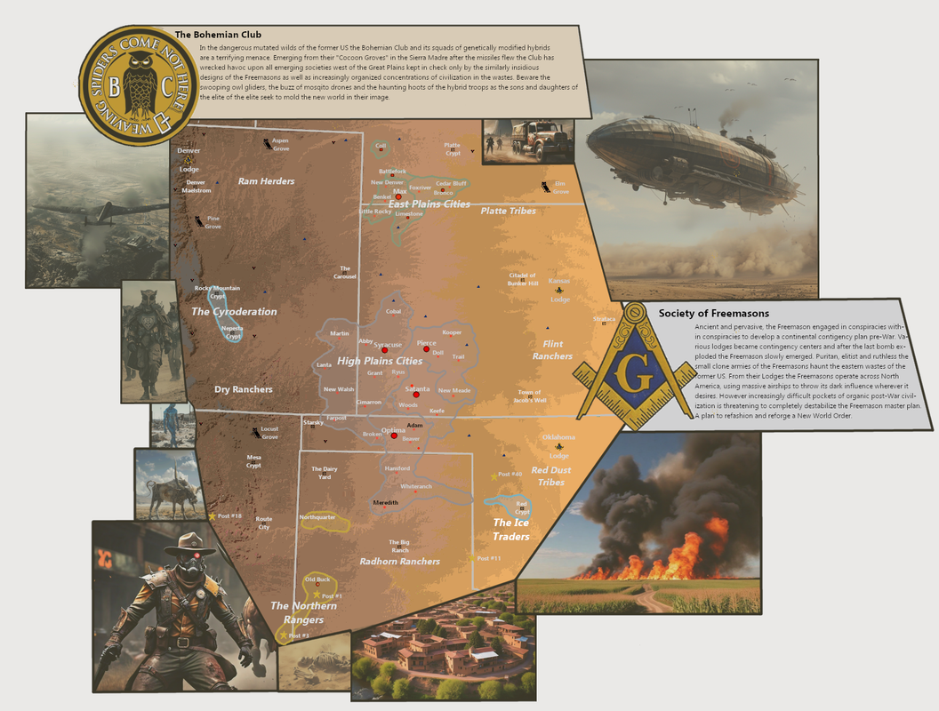
Was working on a world building project strongly inspired by Fallout, Mad Max and the like. Ran into a bit of a snag while making the first main map, I didn't like the layout but had gone too far to change anything. Tragic. Redoing the map and graphics but in the meantime I figured instead of deleting I might as well post it to fish for some helpful critique.

For a very brief write up the premise is that the world goes through intensive renuclearization in the 2030s, blows itself up in the 40s and some 150 years after the bombs stop falling a new world is getting up on its feet. In the context of the map this is the central US where the former states find themselves being the set piece for a continent span war between the Bohemian Club and the Freemasons, with various entities caught in between. With superior technology, weaponry and equipment the super-societies are able to dominate whereever they land but control little beyond their line of fire. The true weight of modern humanity exists in the isolated pockets of cohesive civilization scattered across the wastes, the map showing the East Plains cities of the Republican River and the High Plains cities of the Cimarron, Arkansas and Beaver Rivers.

Fallout-Inspo2.png
 
Last edited:
Was working on a world building project strongly inspired by Fallout, Mad Max and the like. Ran into a bit of a snag while making the first main map, I didn't like the layout but had gone too far to change anything. Tragic. Redoing the map and graphics but in the meantime I figured instead of deleting I might as well post it to fish for some helpful critique.

For a very brief write up the premise is that the world goes through intensive renuclearization in the 2030s, blows itself up in the 40s and some 150 years after the bombs stop falling a new world is getting up on its feet. In the context of the map this is the central US where the former states find themselves being the set piece for a continent span war between the Bohemian Club and the Freemason, with various entities caught in between. With superior technology, weaponry and equipment the super-societies are able to dominate whereever they land but control little beyond there line of fire. The true weight of modern humanity exists in the isolated pockets of cohesive civilization scattered across the wastes, here the East Plains cities of the Republican River and the High Plains cities of the Cimarron, Arkansas and Beaver Rivers.

Fallout-Inspo2.png
Since you're looking for critiques, you might shift the color scheme to be a little darker or maybe a less yellow shade at least for the low elevations. As it stands right now I have difficulty discerning the Freemason symbols in the Eastern part of the map, which is a shame because I do think the colors fit perfectly with the aesthetics of the setting.
 
Since you're looking for critiques, you might shift the color scheme to be a little darker or maybe a less yellow shade at least for the low elevations. As it stands right now I have difficulty discerning the Freemason symbols in the Eastern part of the map, which is a shame because I do think the colors fit perfectly with the aesthetics of the setting.

You know I had really seen that, I prefer the background color as well so I think I may just rethink the map legend scheme entirely.
 
Just how desolate are the rewilded areas? Out of a natural population of 325 million, roughly how many of them live in the preserves vs the regions? Is it just totally empty wilderness between the few cities and roads connecting them?
Approximately 4 million people live in the preserves, the vast majority of whom reside in Las Vegas or Salt Lake City. It is nearly completely wilderness, apart from roads, train lines, immovable infrastructure, and a few outposts of civilization here and there (service stations, historical landmarks, visitor centers, recreation areas). Automated systems maintain any relevant historical sites or districts, while most former towns in the preserve are left to be reclaimed by nature. A few tiny settlements do exist within the preserves, mostly on former Indian reservations.
How were the borders of the preserves decided, and do they signify anything beyond arbitrary lines on a map? The Great Western Preserve is massive, for example, but Olympia and Big Sur are tiny by comparison. Why not break up the former into smaller parcels, or combine all the contiguous preserves into one?
The preserve boundaries were simply designated as such to maintain reasonably sized administrative entities (for use within databases, censuses, etc.) Olympia and Big Sur are tiny as they are exclaves.
You said that people are only allowed to live in the Free and Legacy cities inside the preserves, but are there any off-the-gridders that live illegally in the wilderness?
Yes. It's generally illegal to do so outside of a few designated areas, but people still do it anyways. The government doesn't really prosecute or evict them so long as they aren't bothering anyone.
Since rewilding is still ongoing, where would you say is most likely to be rewilded next? Does the government have an end goal in mind regarding how much of the country they'll rewild?
Rewinding is still ongoing insofar as former cities within the existing preserves are being cleared to make way for new growth nature, but the current preserve boundaries are set in stone. The government is not likely to expand the preserves unless population declines accelerates tremendously.
 
Approximately 4 million people live in the preserves, the vast majority of whom reside in Las Vegas or Salt Lake City. It is nearly completely wilderness, apart from roads, train lines, immovable infrastructure, and a few outposts of civilization here and there (service stations, historical landmarks, visitor centers, recreation areas). Automated systems maintain any relevant historical sites or districts, while most former towns in the preserve are left to be reclaimed by nature. A few tiny settlements do exist within the preserves, mostly on former Indian reservations.

The preserve boundaries were simply designated as such to maintain reasonably sized administrative entities (for use within databases, censuses, etc.) Olympia and Big Sur are tiny as they are exclaves.

Yes. It's generally illegal to do so outside of a few designated areas, but people still do it anyways. The government doesn't really prosecute or evict them so long as they aren't bothering anyone.

Rewinding is still ongoing insofar as former cities within the existing preserves are being cleared to make way for new growth nature, but the current preserve boundaries are set in stone. The government is not likely to expand the preserves unless population declines accelerates tremendously.


Well if nothing else that would be a tremendously beautiful dystopia.
 
Well if nothing else that would be a tremendously beautiful dystopia.
Much depends on if the nature preserves followed a heavy demographic collapse or the places were forcibly depopulated.

If the former, the question is why the population contracted hard enough for the U. S. to give up on the state structure....
 
Much depends on if the nature preserves followed a heavy demographic collapse or the places were forcibly depopulated.

If the former, the question is why the population contracted hard enough for the U. S. to give up on the state structure....

Definitely that would tell us the degree of dystopia but either way its a sad looking world.
 
Top